
Pierre Mortier’s unique world map drawn on Mercator’s projection with California as an Island and the Detroit d’Anian connected by dotted lines through the Northwest Passage to Button’s Bay located to the west of Hudson Bay.
A small coastline of New Zealand appears in the Pacific. The northeast coast of Asia is severely truncated and shows Witsen’s Cap de Glaces. Australia’s northern coast is shown connected to New Guinea, along with a part of Van Diemen’s Land.
The most interesting features of the map are the five spheres presented at top. These depict Day and Night, the Flood, the phases of the moon, and the Western and Eastern Hemispheres.
The map was precisely engraved by Jan van Luchtenburg (signature at lower left).
Dutch title: Generale Waereld Kaart, of Beschryving van de Land en water Waereld.
Techniek: handgekleurde kopergravure, kleuring modern.
Afmeting: ca 40 x 47 cm
Conditie: uitstekend, luxe gelijst
Prijs op aanvraag / Price on request
xxxxxxxxxxxxxxxxxxxxxxxxxxxxxxxxxxxxxxxxxxxxxxxxxxxxxxxxxxxxxxxxxxxxxxxxxxxxxxxxxxxxxxxxxxxxxxxxxxxxx
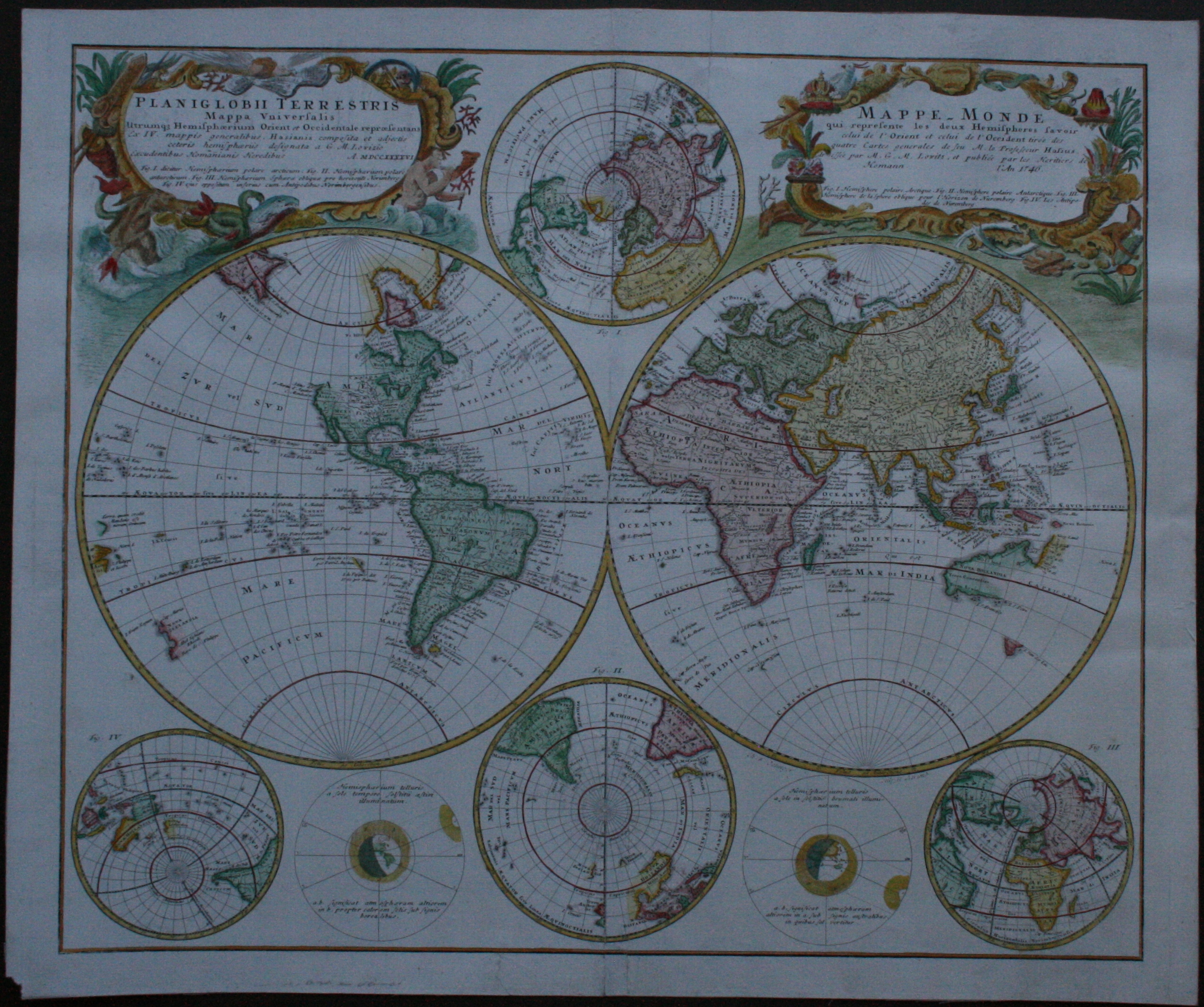
Planiglobii Terrestris Mappa Universalis Utrumqs Hemisphaerium Orient et Occidentale
Copper engraving published by the Homann heirs of Neuremberg in 1746.
Coloured by a later hand.
Size: 44,2 x 52,9 cm.
Condition: professional laid down on Japanese ricepaper with some closed unobtrusive tears
Double hemisphere map of the world, with four globes tangential to the hemispheres show earth from various angles in addition to the expected polar views.
Two diagrams explain the effect of the Sun on different parts of the world.
North America is still blank above California and Hudson Bay is open-ended in the north-west corner.
This map blends the science, cartography and art of the day in a most interesting and attractive way.
The map was compiled by Johannes Hasius, professor of mathematics at the university of Wittenberg and included the geographical-astronomical observations of Georg Moritz Lowitz.
It includes incomplete Australia and New Zealand, a fanciful Northwestern coast of America based upon the early Russian explorations, and mythical images of the Poles.
Price: € 1.450
xxxxxxxxxxxxxxxxxxxxxxxxxxxxxxxxxxxxxxxxxxxxxxxxxxxxxxxxxxxxxxxxxxxxxxxxxxxxxxxxxxxxxxxxxxxxxxxxxxxxxxxxxxxxxxxxxx